Through various programs, NASA develops projects aimed at transforming satellite observations into practical information for land management, natural resources, and infrastructure. In this post, we will focus on OPERA (Observational Products for End-Users from Remote Sensing Analysis), an initiative that produces ready-to-analyze data from optical and radar imagery.
Throughout the article, we will explore the scope of this project, the key actors involved in its development, and how its products can be applied across different fields, highlighting those most relevant to civil engineering and geotechnics.
What is OPERA DISP?
OPERA (Observational Products for End-Users from Remote Sensing Analysis) is a NASA project led by the Jet Propulsion Laboratory (JPL) that began in April 2021.
Its main goal is to produce analysis-ready data products from optical and radar satellite observations, addressing the needs of U.S. government agencies as identified by the NASA Satellite Needs Working Group (SNWG).
NASA's OPERA produces ready-to-analyze data products from both optical and radar satellite imagery, supporting government agencies and collaborating with research centers and universities.
The project is managed by JPL (Caltech) in collaboration with other NASA centers, such as the Goddard Space Flight Center, the U.S. Geological Survey (USGS), and universities. For example, the University of Maryland (Matt Hansen’s GLAD lab) contributed to the development of change-detection algorithms, while USGS scientists provided expertise in surface water detection.
OPERA was created to provide remote sensing–derived products that support environmental monitoring and disaster response. In particular, three main types of Level-3 (final derivative) products have been identified, focused on:
- Dynamic Surface Water Extent: Mapping surface water almost in real time (30 m resolution) by combining optical and radar imagery, supporting water management, emergency response, and environmental studies.
- Surface Change Detection: Detects abrupt changes on the Earth’s surface (deforestation, wildfires, droughts, landslides) with 30 m resolution and near real-time alerts at a global scale.
- Surface Displacement or Movement: Monitors surface displacements and deformations.
These products integrate data from synthetic aperture radar (SAR) and optical satellites to provide actionable information for end users, such as in water resource management, ecosystem change monitoring, and geological hazard control (subsidence, earthquakes, landslides).
Two of OPERA’s products have near-global coverage, spanning almost all continents except Antarctica.
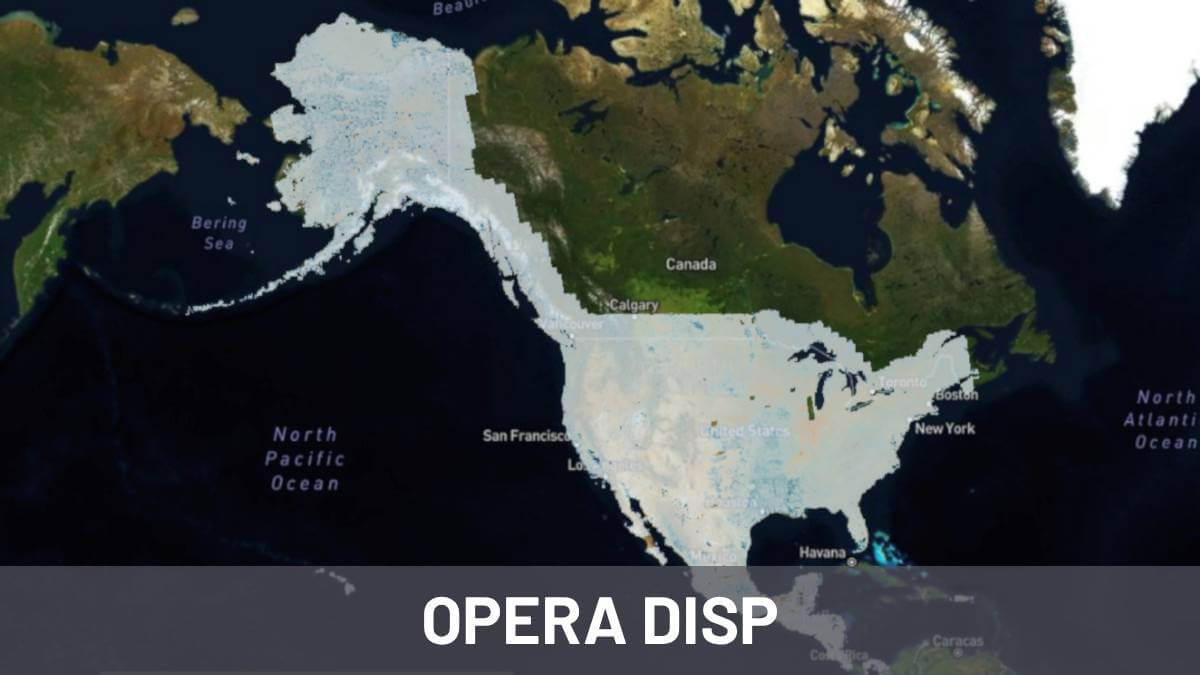
The third product, focused on ground deformation, covers North America, defined as the United States (including U.S. territories), Canada up to ~200 km from the U.S. border, Mexico, and the other continental countries down to Panama.
OPERA products combine optical and radar data to provide information on water resources, ecosystems, and geological hazards, with near-global or continental coverage depending on the product. OPERA delivers data at continental and global scales to support a wide range of large-scale applications.
Below, we briefly describe these three OPERA products and their main features. Once the three products are outlined, we will focus in detail on the one most relevant to Detektia: the ground displacement product, known as DISP within the OPERA project.
What are the main OPERA products?
OPERA’s Level-3 products are derived, ready-to-use data for end users, generated from combinations of optical and SAR satellite data. As mentioned, there are currently three main product suites:
DSWx: Dynamic Surface Water Extent
OPERA’s DSWx (Dynamic Surface Water Extent) product enables frequent mapping of surface water (lakes, rivers, wetlands, and floods) at 30 m resolution, providing near real-time data for water resource management, emergency response, and environmental studies.
It draws on both optical imagery (Landsat 8/9 and Sentinel‑2 via the Harmonized Landsat and Sentinel‑2 product) and SAR data (Sentinel‑1 and, soon, NISAR), ensuring near-global coverage even in areas with persistent cloud cover.
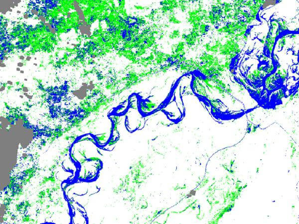
Each pixel is updated on average every 2–4 days, reaching an almost daily cadence in many regions.
DSWx monitors lakes, rivers, wetlands, and floods almost in real time with 30-meter resolution, combining optical and radar data to provide global coverage and frequent updates.
The algorithm combines spectral indices and radar techniques to distinguish water from soil and vegetation, also incorporating auxiliary layers such as probability, clouds, and DEM.
DSWx was launched in 2023 in its optical version and will be expanded with radar data in the coming months.
DIST: Surface Change Detection
The DIST product from OPERA detects alterations and changes on the Earth’s surface, primarily vegetation loss or other abrupt deviations from the norm, generating near real-time alerts on a global scale.
It is based on the Harmonized Landsat and Sentinel‑2 optical time series with 30 m resolution and updates every 2–4 days, enabling the identification of deforestation, wildfires, agricultural or urban expansion, droughts, landslides, and pest outbreaks.
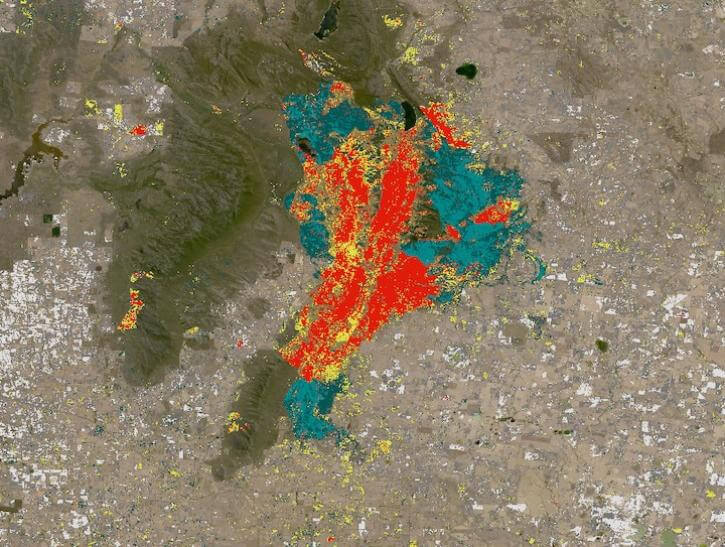
The DIST‑ALERT system compares each new image with a three-year baseline to distinguish real changes from seasonal variations and can update an alert within just six hours of receiving a new scene.
DIST detects abrupt changes on the Earth's surface almost in real time, from deforestation and wildfires to droughts and landslides, with 30-meter resolution and global coverage, supporting environmental management and early warning systems.
Additionally, an annual product, DIST‑ANN, consolidates all confirmed disturbances over the year. Its coverage is near-global (except Antarctica), and it has already been integrated into platforms such as Global Forest Watch, facilitating environmental monitoring and risk management across diverse ecosystems.
DISP: Surface Displacement
Finally, the surface displacement and deformation product, known as DISP within the OPERA project, has inspired this blog post.
Due to its importance and impact on sectors such as civil engineering, we will analyze it in depth in the following section.
DISP monitors surface displacements and deformations, providing crucial information for civil engineering and infrastructure management. We explore it in more detail below.
All about OPERA’s DISP Product
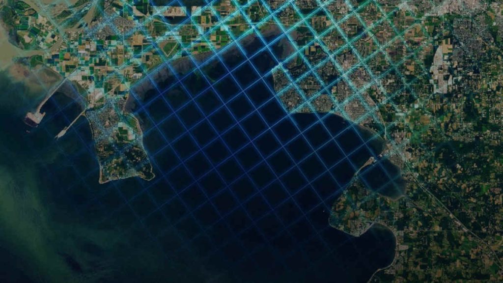
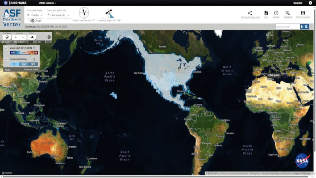
DISP provides ground deformation data at a continental scale.
It is a product comparable to the European Ground Motion Service (EGMS) in terms of impact, extent, and coverage, and even surpasses EGMS in aspects such as update frequency.
The DISP product delivers information on the evolution of ground surface deformation using radar interferometry (InSAR) over time.
It is initially focused on the North American region (as defined, including the U.S., southern Canada, and Central America down to Panama), thus providing continental-scale ground deformation measurements.
DISP measures ground deformations at a continental scale in North America, detecting subtle or abrupt movements caused by natural or human factors, with high resolution and regular updates.
The goal is to detect and quantify subtle or abrupt ground movements caused by natural or human activities, such as subsidence from water or underground extraction, tectonic deformation associated with earthquakes or active faults, volcanic uplift or subsidence, landslides, and even deformation from infrastructure loads or mining activities.
In short, this product provides an integrated view of changes in ground elevation with high spatial resolution and regular updates.
Detektia is a tech company specializing in InSAR satellite technology, offering solutions to identify and quantify ground subsidence. We can help you monitor:


DISP Satellites and Input Data
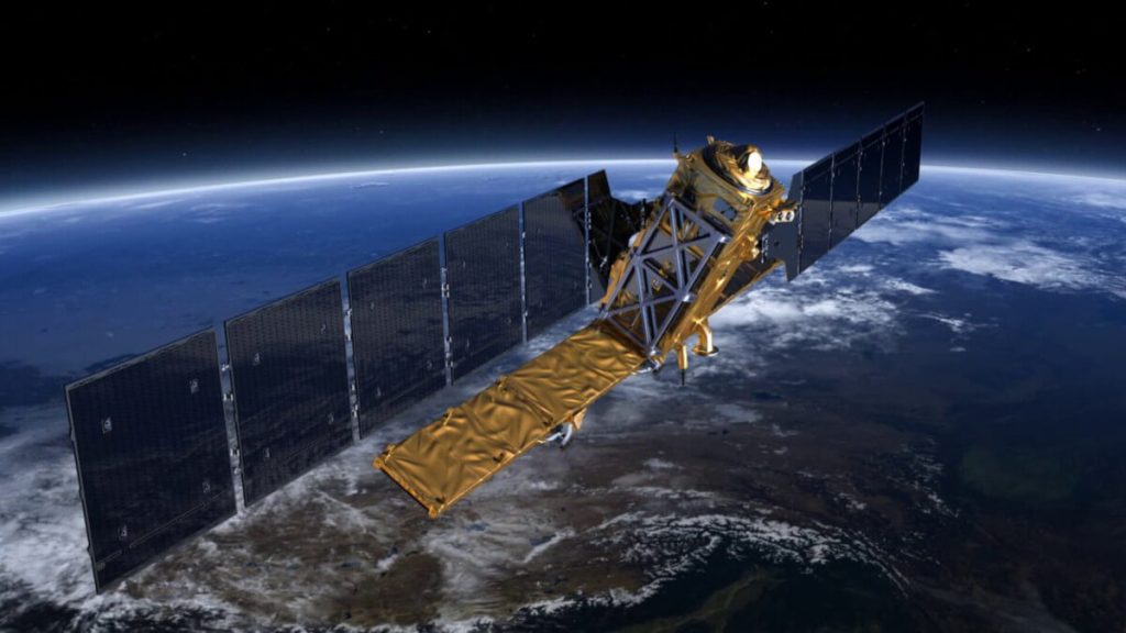
To generate DISP, OPERA uses InSAR data from Sentinel‑1 radar (Sentinel‑1A and 1B satellites) and will incorporate NISAR data in the future.
Sentinel‑1 provides C-band (~5.4 GHz) SAR imagery in Interferometric Wide swath (IW) mode with a 6-day revisit (with both satellites, before the loss of S1B in 2021) or 12-day revisit (currently with only S1A active).
OPERA uses coregistered Sentinel‑1 SLC (Single Look Complex) products (see Level‑2 section below) as the main input. In other words, the complex radar images, already aligned to a common grid, are processed in a time series to extract the interferometric phase corresponding to ground displacements.
DISP is generated from InSAR data from Sentinel-1 and, soon, NISAR, processing radar time series to measure ground displacements with high precision and improved coverage.
NISAR (which will operate in L-band, ~1.2 GHz) will complement the time series starting in 2025, improving coherence in vegetated areas and potentially expanding the temporal and spatial coverage of the products (possibly beyond North America, if resources allow).
Displacement products derived specifically from Sentinel‑1 are labeled DISP‑S1, while future products including NISAR data will be designated DISP‑NI.
Geographical coverage
The coverage of this product is broadly defined as North America: it includes the entire territory of the United States (continental and insular territories), Canada (areas up to 200 km from the U.S. border), Mexico, and Central America down to Panama.
This area aligns with the priority requirements initially identified by U.S. agencies through the SNWG to monitor critical infrastructure, geological hazards, and resources within the country and surrounding region.
DISP covers North and Central America up to Panama, including the continental and insular U.S., Canada (~200 km from the border), Mexico, and Sentinel‑1 tracks for infrastructure monitoring and geological hazard assessment.
Within this region, displacement products are generated for all available Sentinel‑1 tracks, including Alaska, Hawaii, Puerto Rico, and other U.S. territories.
Spatial resolution
The spatial resolution is 30 m. Although Sentinel‑1’s original Single Look Complex (SLC) images have a nominal resolution of approximately 10 m (ranges around 5 × 20 m before multilooking), the final OPERA displacement product is gridded at 30 m in UTM coordinates.
This approach reduces noise and data volume, and facilitates integration with other OPERA products that also use 30 m resolution, such as DSWx and DIST.
DISP has a 30 m resolution, optimized to reduce noise and facilitate integration with other OPERA products, with each pixel representing accumulated displacement or ground velocity.
Essentially, each 30 m pixel in DISP contains the estimated cumulative displacement (or velocity) for that area. Even at 30 m resolution, localized deformations (e.g., subsidence over wells) can be detected as long as they span multiple pixels.
Update frequency
The update frequency matches Sentinel‑1 overpasses, typically every 6 to 12 days, depending on whether the area is covered by a single track or two satellites.
In regions with both ascending and descending coverage, there will be two different line-of-sight observations per cycle.
OPERA generates a displacement product for each new significant acquisition in the time series. In other words, as a new SLC image becomes available, it is integrated into the temporal InSAR processing, producing an update.
The historical time series dates back to mid‑2016 (when Sentinel‑1 achieved full coverage of the U.S.) and continues from there.
DISP is updated every 6–12 days depending on Sentinel‑1 coverage, integrating each new image into the time series since 2016 to analyze both historical trends and recent events.
In this way, OPERA plans to provide a set of displacement products from 2016 to the present, allowing users to analyze long-term trends as well as recent events shortly after they occur. Specifically, in DISP‑S1 version 1, the input data spans from July 2016 to 2025, and the collection will continue to expand with each new image (at a rate of 6–12 days per region).
Algorithm and methodology used
The DISP product is generated through advanced InSAR time-series analysis, using a hybrid approach that combines Persistent Scatterer (PS) and Distributed Scatterer (DS) techniques.
The processing identifies both persistent scatterers (pixels with highly coherent backscatter over time, typically buildings, exposed rocks, etc.) and distributed scatterers (natural surfaces that maintain statistical coherence when averaging multiple pixels, e.g., soil or homogeneous vegetation) to extract deformation signals while minimizing noise.
DISP uses a hybrid InSAR analysis combining persistent and distributed scatterers, generating radar line-of-sight displacement time series with minimal interference and noise.
The result for each track is a time series of displacements in the radar line-of-sight (LOS) direction. DISP products typically represent cumulative deformation or deformation velocity.
How to get the most out of it
The surface displacement product is especially valuable in civil engineering and geotechnics, as well as in geophysics and risk management.
Thanks to this product, it is possible to identify areas of urban or agricultural subsidence (due to groundwater extraction, mining, or soil compaction) and monitor the stability of civil infrastructure (roads, bridges, levees, dams, buildings) by detecting differential settlements.
It also enables monitoring of coastal areas or deltas prone to subsidence, mapping deformation in seismic zones to understand active faults and quantify interseismic or coseismic deformation after an earthquake, tracking volcanic inflation/deflation for early eruption warning, and detecting active or potential landslides (precursory movements).
DISP is essential in engineering, geotechnics, and risk management, enabling the monitoring of subsidence, infrastructure stability, seismic and volcanic activity, and landslide detection, supporting mitigation and planning decisions.
Organizations such as the USGS, transportation departments, water management agencies, and civil protection authorities can integrate these data for decision-making and prioritization of mitigation measures.
For example, DISP can help delineate basins where the ground is sinking several millimeters per year due to groundwater overexploitation, or detect areas of a city experiencing accelerated subsidence, indicating risks to structures.
Temporal availability
The DISP‑S1 product (Sentinel‑1) is already available for users to access version 1 of the L3_DISP‑S1 product across much of the U.S., all of Mexico, and Central America.
Once NISAR becomes operational (launch expected in 2025), the DISP‑NI product will be added to complement deformation detection, especially in densely vegetated areas thanks to its longer wavelength.
DISP‑S1 is already available for much of North and Central America, and in 2025 DISP‑NI will incorporate NISAR data to improve detection in vegetated areas and potentially expand geographic coverage.
It is possible that the geographic coverage will be expanded in the future using NISAR (potentially to near-global coverage), but the initial focus is on North America due to the project’s original requirements.
Data access: how to download DISP data
DISP products are distributed through the Alaska Satellite Facility DAAC (ASF DAAC). This includes access via the ASF Vertex search and download interface, as well as through AWS S3 (ASF public bucket).
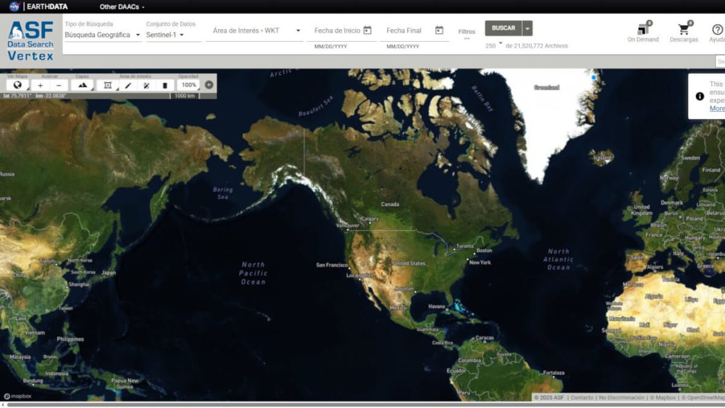
It is also possible to download all OPERA data using the NASA Earthdata Search web tool, a general search engine for NASA Earth Science collections.
The following video, shared on the @NASAEarthdata YouTube channel, provides a step-by-step guide on how to use the ASF Vertex platform to search for and download OPERA DISP surface displacement data.
References and further reading
- OPERA-DISP ToolBox: https://displacement.asf.alaska.edu/#/?dispOverview=VEL.
- Observational Products for End-Users from Remote Sensing Analysis (OPERA): https://asf.alaska.edu/datasets/daac/opera/.
- OPERA Surface Displacement from Sentinel-1 validated product (Version 1): https://registry.opendata.aws/nasa-operal3disp-s1v1/.