
Structural health monitoring in dams
- Early warning system
- Satellite-based InSAR technology
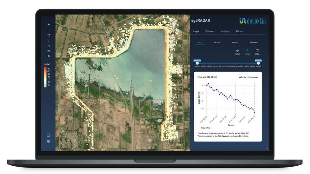
DInSAR technology supports new and more effective methods of monitoring and analyzing dams’ integrity and trigger warning systems. Detektia’s near real-time tools provide valuable information with large sensitivity to displacements that highlight the behavior and anomalies of these structures.
We provide information where instrumentation or topography campaigns do not reach, we double check in places where we do have in situ data, we increase the temporal resolution of the measurements, we correlate deformation with temperature, reservoir level, piezometry or other variables.
Our clients
Do you think you could get a more complete picture of the dam's behavior?
We have worked with many dam managers over the years and it is recurring. Satellite radar technology helps them understand more deeply and clearly the behavior of the dams they manage. New technologies, new data and new ways of analyzing are a big step forward in the control and management of water infrastructure.

Candela Sancho
CEO de Detektia
Our projects
Can we help you?
More information
What is dam monitoring?
The auscultation of a dam is the procedure that allows to evaluate the state and conditions of this infrastructure. Its objective is the early identification of any anomaly and to guarantee the safety and correct condition of the dam.
This process has traditionally been carried out with in situ instrumentation.From Detektia we offer complementary solutions based on satellite InSAR technology that allow the auscultation of dams remotely.
What solutions do we offer for dam control?
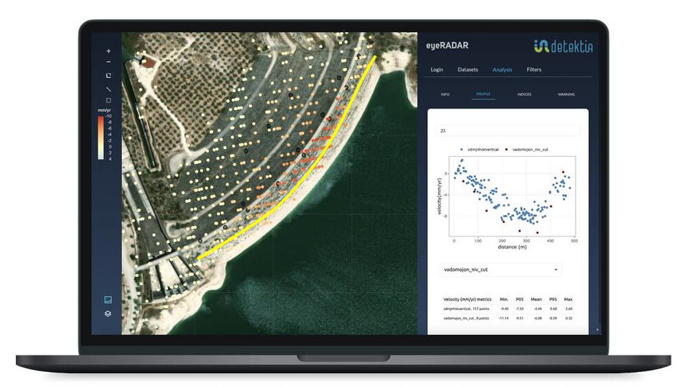
Detektia's solution is based on InSAR satellite technology and artificial intelligence. InSAR measures deformations with millimeter precision in both the dam and the reservoir slopes. Our solution also includes an alert system that detects unexpected deformations.
Our solution allows the analysis of the deformation time series together with other concomitant variables that may be affecting the deformation such as temperature, precipitation or reservoir level.
Safety systems for deformation control
Dam safety systems are based on the synchronized and coordinated action of different technical disciplines in order to guarantee the safety and health of these infrastructures. These systems must be applied from the design, construction and maintenance phases of the dams.
Satellite information provides an additional level of safety over the life of a dam.It adds an extra layer of control, surveillance and deformation detection in dams and slopes.
Our proposal for deformation control
Detektia's technology complements the traditional dam monitoring system by analyzing correlations between variables and continuously identifying anomalies in the deformation process occurring in nearby dams or slopes.
This system reduces maintenance costs by detecting anomalies early. In hydraulic infrastructures that do not have an auscultation system (or it is very precarious), InSAR technology is the only way to reconstruct their historical behavior.