
Detection of overexploitation in aquifers
- No on-site instrumentation or installation
- 100% remote with satellite technology
- Continuous monitoring
- With millimetric precision
Overexploitation of aquifers causes water shortages, reduces water quality and causes ground movements, affecting surface topography and infrastructures. Overexploitation of groundwater can generate continuous land subsidence which, in some cases, affects large areas and even collapses urban structures.
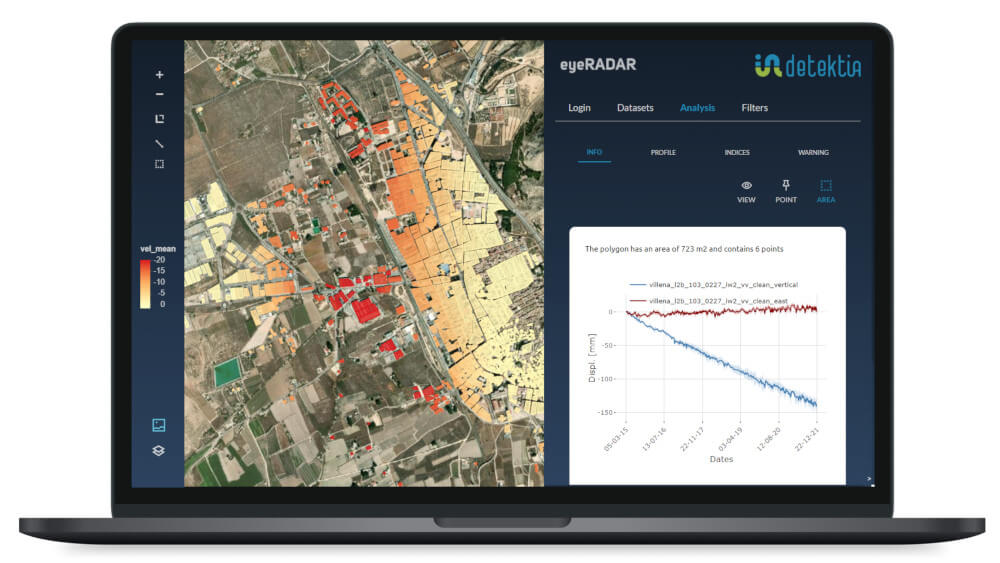
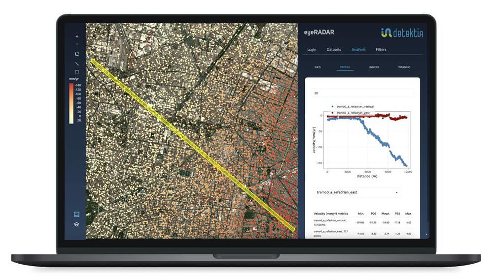
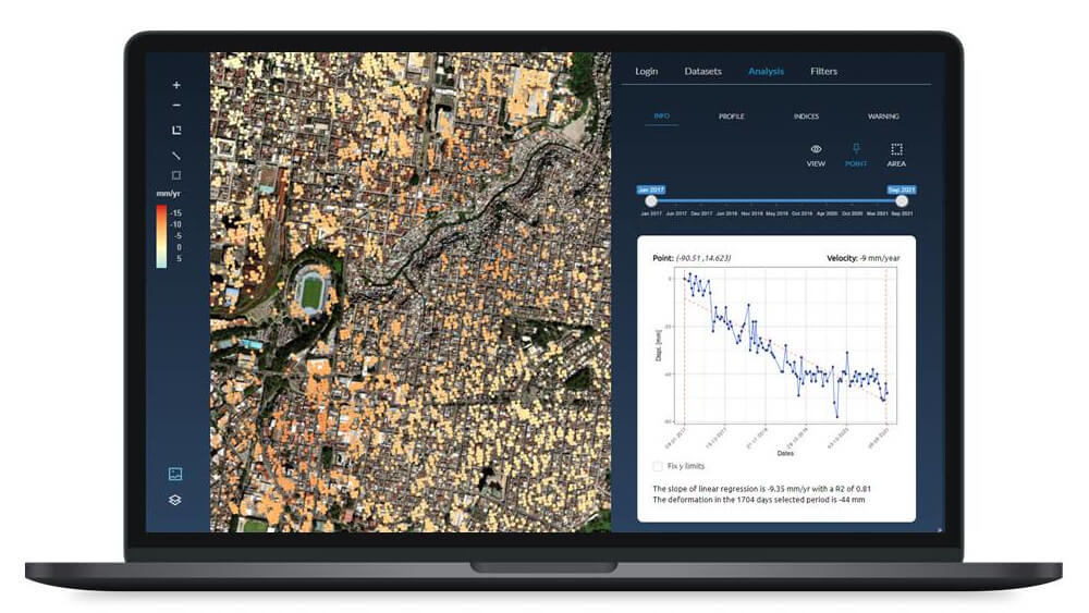
DInSAR technology measures (with millimeter accuracy and without ground-based instrumentation) the surface deformation of the ground, providing valuable information to describe the dynamics of loading and discharge cycles in detrital aquifers.This high spatial and temporal resolution information can substantially improve decision making in groundwater management.
Our clients
Prevention and monitoring of aquifer exploitation
Mexico City is sinking 25 cm/year, similar to the rates in Jakarta and Manila, where sea levels are also rising due to climate change.Closer to us, in the Region of Murcia, we have the highest rate of land subsidence in Europe (10 cm/year) caused by overexploitation of aquifers. Groundwater is a scarce and dispersed resource, so its control and management is a major challenge. In Spain alone there are more than 500,000 illegal wells that extract the equivalent of the annual consumption of 58 million people. Worldwide, 20% of the world’s aquifers are overexploited and the figure continues to grow.

La extracción de agua subterránea en los acuíferos detríticos genera hundimientos inducidos en la superficie del suelo, mientras que la recarga del acuífero provoca el levantamiento de la superficie. Los métodos de monitorización y detección de subsidencia tradicionales ofrecen información valiosa, pero en muchos casos no son suficientes o no garantizan la detección de forma temprana para una correcta toma de decisiones.
Desde Detektia te ofrecemos nuevas herramientas para controlar eficazmente la sobreexplotación de los acuíferos en grandes áreas a un coste competitivo.

Candela Sancho
CEO de Detektia
Our projects
Can we help you?
More information
What does monitoring of aquifer exploitation consist of?
The overexploitation of aquifers generates serious problems. From the appearance of ground subsidence with the consequent deterioration of surface infrastructures to the contamination of groundwater.
Monitoring aims to efficiently manage water extraction to prevent overexploitation and thus avoid irreversible damage.
What solutions do we offer to monitor the overexploitation of aquifers?
Traditional measurement and detection methods require the installation of in-situ piezometers. Although these provide reliable information, they are generally not very scalable as they provide information from very specific areas.
The solution offered by Detektia is complementary to traditional measurement methods. Based on satellite technology, they provide a much clearer picture of the state of health of aquifers, cover very large areas and facilitate the early detection of any alteration.
The importance of groundwater abstraction monitoring
We speak of overexploitation of aquifers when a quantity of water is withdrawn in excess of the naturally generated recharge. This prolonged activity can lead to the drying up of wells or springs, deterioration of water quality and subsidence of the surface (which in turn can lead to damage to infrastructures).
Continuous monitoring of the condition and exploitation of these subway structures is vital to avoid the aforementioned consequences.
Paradigm shift, our approach to well monitoring and management
A few years ago it would have been unthinkable to have hundreds of thousands of deformation time series. Today, thanks to satellite information, we can visualize on a map the complete point cloud colored by the average deformation velocity in the analyzed period.
Thanks to machine learning algorithms, we can know in which areas, at what time and with what magnitude there has been anomalous behavior. This information is key to efficiently and continuously monitor groundwater extraction.