Remote sensing based ground motion assessment
Differential Interferometry Synthetic Aperture Radar technology offers up-to-date and historical information on the behavior of the ground at any point of the planet. Ground historical deformation time series can be generated since the early 1990s for any area of the planet without the need for ground instrumentation, regardless of its accessibility, extension of the study area and climatic conditions, obtaining point densities that are unreachable with traditional topography methods.
Our Works
Groundwater dynamics
Freshwater underground sources are being depleted at an accelerating rate (triple than the historical average) due to population growth, increasing irrigating crops and climate change (USGS, 2013). However, substantial parts of the globe’s groundwater resources are uncharted. An accurate understanding of the charge/discharge dynamics and status of groundwater is crucial to enhance its precise management and sustainability, especially in arid and semi-arid areas. Our technology provides valuable information for understanding aquifer loading and unloading dynamics.


Landslides & slope stability
Events resulting from slope instability (such as landslides, landslides and flows) are responsible for major catastrophes worldwide. These disasters cause numerous casualties and heavy economic losses, with their impact being greater in developing countries. InSAR technology allows, in addition to identifying slopes and areas with a high degree of instability, to accurately measure both the historical behavior of the slope and the movements prior to landslide events. This information combined with other sources of information (such as terrain slope, geology, precipitation…) allows the implementation of early warning systems of great value for the prevention of these disasters.
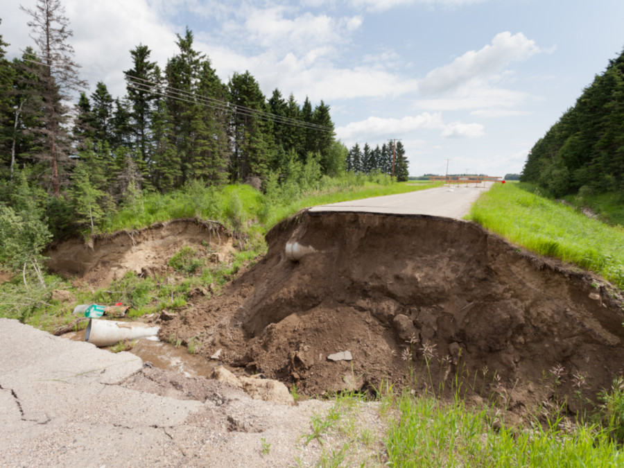
Sinkholes
Sinkholes are sudden ground collapses caused by the weakening of the subsurface, either due to natural processes such as erosion and water infiltration, or human activities like mining. They pose a serious risk to infrastructure and public safety. InSAR technology, when combined with precipitation, geological, and topographic data, enables the accurate and large-scale detection of ground deformation, facilitating the early identification of vulnerable areas and the implementation of preventive measures to mitigate risks.
EyeRADAR is the all in one ground movement monitoring software
Manage all ground motion information with EyeRADAR. It includes an early warning system, deformations time series (historical and updated ones) as well as multiple structural health indices. No installation is required as it is completely online. Already have software? We can help you integrate it with EyeRADAR and use its full potential from your own environment.

Can we assist you?
More information
Why do we assess soil stability?
Soil movements are important issues to take care about. They could affects the integrity of buildings and constructions, could increase the risk of flooding and cause huge economic losses.
The importance of ground deformation monitoring
Continuous monitoring and analysis of ground deformation is a mandatory task in order to build a useful early warning system.
Get surface instability reports on real time
The implementation and integration of an artificial intelligence layer over satellite time series is a key factor that allows reporting in a totally objective and near-real time manner the anomalous and unexpected movements of the ground. Comparison of previous and current movements allows for the automatic detection of anomalous movements.
Take advantage of our land subsidence early warning system
Detektia develops dynamic early warning systems combining non-intrusive remote sensing technology with other variables such as rainfall, geology, slope, piezometric level, geometry of embankments… The results of our models vary in almost real time depending on these dynamic variables.
Non-intrusive monitoring and early warning system
Going beyond measurement and reporting, detecting early changes in the behavior of the ground. The main characteristics of our technology are:
Millimeter accuracy, no need for ground instrumentation and constant updates.
DInSAR technology measures small millimeter variations on any surface without the need of ground instrumentation.
High-density control points.
We obtain an exponential increase in the density of control points compared to traditional instrumentation campaigns.
Digitalization and online access.
All interested actors can easily access, share and analyze the deformation data, warnings and risks maps through our API and web platform.
Historical monitoring.
In many geographical regions, there is data since the 1990s allowing the creation and analysis of time series of long- term movements of the ground.
Artificial Intelligence.
AI allows reporting in a totally automatic, objective and near-real time manner the anomalous and unexpected movements of the ground, slopes and infrastructures.