- May 2019 - April 2020
- Sardoba (Uzbekistan)
- Ascending & Descending
- Sentinel-1
- Dams
In this study, DInSAR technology was used to measure the deformations that occurred at the Sardoba Dam prior to its failure in May 2020. The generation of time series of displacements from both satellite acquisition geometries (ascending and descending) made it possible to decompose the movements into vertical and East-West horizontal components. The results reveal a differential deformation pattern in the eastward direction, precisely in the failure zone.
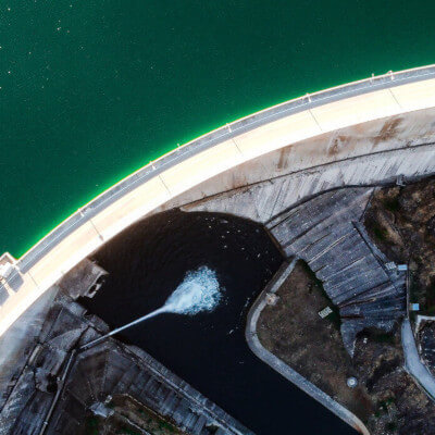
Collapse of the Sardoba Dam in Uzbekistan
On May 1, 2020, a large section of the Sardoba Dam in the Sirdaryo region of Uzbekistan collapsed, flooding more than 35,000 hectares across Uzbekistan and Kazakhstan.
Six people lost their lives, and at least 111,000 residents were evacuated from the Syr Darya River basin.
Sardoba dam break analysis
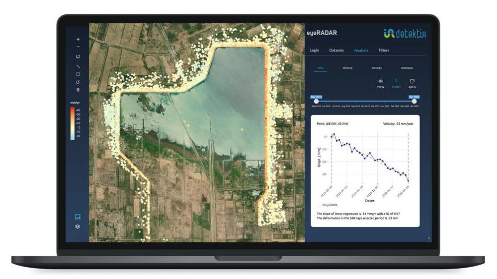
In this study conducted by Detektia, deformations in the dam walls prior to the collapse were evaluated using DInSAR technology, based on 27 Sentinel-1A images in descending geometry and 31 in ascending geometry, covering the period from May 2019 to April 2020.
At the time of analysis, Sentinel-1 had been in operation for five years, providing a series of free and high-quality SAR images suitable for processing.
The ascending geometry results already revealed significant indications. In this geometry, most of the dam wall where the breach occurred appeared stable or slightly moving toward the satellite. However, a specific section of the wall—the breach zone—showed a movement away from the satellite at a rate exceeding 25 mm/year.
🛰️ A clear pattern of deformation before rupture is observed in this InSAR analysis.
These differential deformations were clearly evident prior to the collapse. The following figure clearly illustrates this behavior in ascending geometry:
We did not limit ourselves to a single geometry: we also processed and analyzed images acquired in descending geometry.
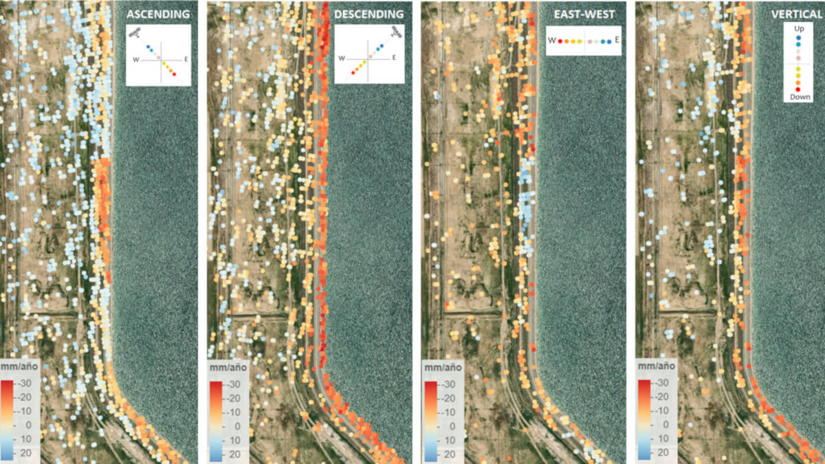
Observing the dam’s movements from both satellite acquisition geometries makes it possible to decompose the deformations into two components: vertical and East-West horizontal. These well-known axes of motion allow for a clearer interpretation of the results.
The figure below shows the deformation velocities (in mm/year) for both ascending and descending geometries, as well as the vertical and East-West components.
Due to the direction and magnitude of the deformation, the differential movement in the failure zone is not clearly visible in the descending geometry, which underscores the importance of working with both geometries.
Had we relied solely on descending geometry, the anomalous behavior of the dam would have gone virtually unnoticed.
📈 Analyzing both geometries (ascending and descending) was crucial to identifying the true deformation pattern prior to the collapse.
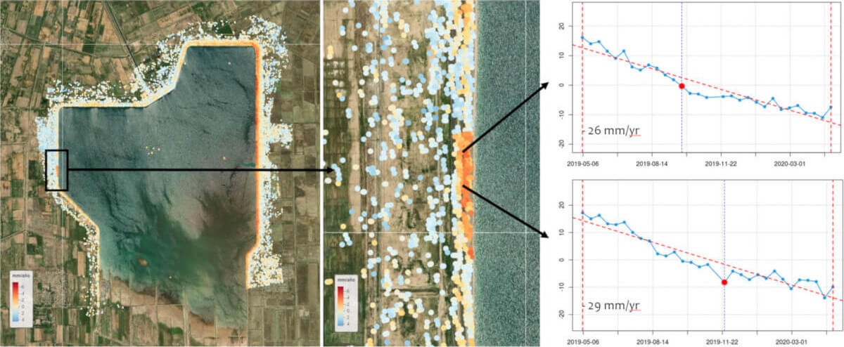
Although the breach section is located on a wall with a slight westward displacement, this specific section exhibited a clear deformation pattern toward the east, consistent with the pre-collapse dynamics. The following figure shows differential movements in both the vertical and horizontal (East-West) components:
Other Studies Conducted Using InSAR
This scientific article published in 2022 analyzes, using InSAR technology, the deformations leading up to the failure of the Sardoba Dam.
Although the results presented are similar to ours, the discussion on the causes of the collapse is particularly insightful.
The study concludes that the failure resulted from a combination of physical and human factors. The main physical factor identified is internal erosion, evidenced by differential movements in the failure zone recorded two and a half years prior to the collapse. These differential settlements led to cracks that facilitated seepage and the progressive deterioration of the structure.
From a human perspective, the article points to a lack of adequate monitoring. Conventional methods—based on point measurements and visual inspections—were unable to detect the progressive deformation. Although internal erosion is difficult to detect, differential settlement served as a key indicator that went unaddressed, preventing timely preventive action.
The article also rules out rainfall as a trigger, noting that there were no extreme precipitation events prior to the failure. The dam, a regulating structure, receives water from the Syr Darya River via canals, not directly from surface runoff. The reservoir level increase was due to planned operations, not rainfall.
In summary, the collapse was likely caused by internal erosion triggered by differential settlements, worsened by the lack of monitoring and response.
At Detektia, we can help you continuously monitor dams and other infrastructure. InSAR technology allows us to detect even the slightest deformations at an early stage. In the case of the Sardoba Dam, InSAR monitoring could have prevented the catastrophe: