- February 2017 - September 2021
- Guatemala City (Guatemala)
- Ascending & Descending
- Sentinel-1
- Aquifers
InSAR technology provides valuable insights in cities that rely on groundwater for their supply. The exploitation of aquifers can lead to ground deformation, which, in urban environments, affects all types of infrastructure. Moreover, monitoring surface deformation with InSAR offers high-resolution data on fluctuations in the water table, and therefore on the rate of groundwater extraction and recharge. In this study, we analyze ground deformation in the Guatemala City Valley.
The Guatemala City Valley can be defined as a graben bounded by the Pinula Fault to the east and the Mixco Fault to the west. The Guatemala Metropolitan Area (GMA) had a population of over 5 million inhabitants in 2015, making it the largest urban center in Central America and the 89th largest metropolitan area in the world.
The exploitation of the aquifer beneath the GMA accounts for more than 50% of the total water used for municipal supply. Ground subsidence caused by aquifer extraction depends on both the local geology and the intensity of groundwater withdrawal.
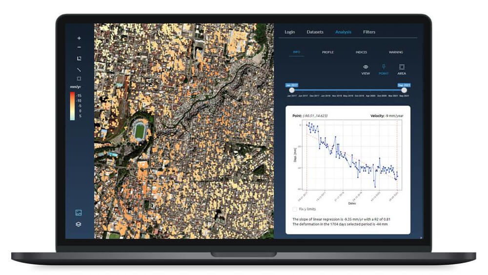
At Detektia, we conducted an InSAR (Interferometric Synthetic Aperture Radar) analysis describing ground deformations in the GMA from January 2017 to September 2021. A total of 580,872 persistent scatterer points were obtained, each with a full time series of deformation data.
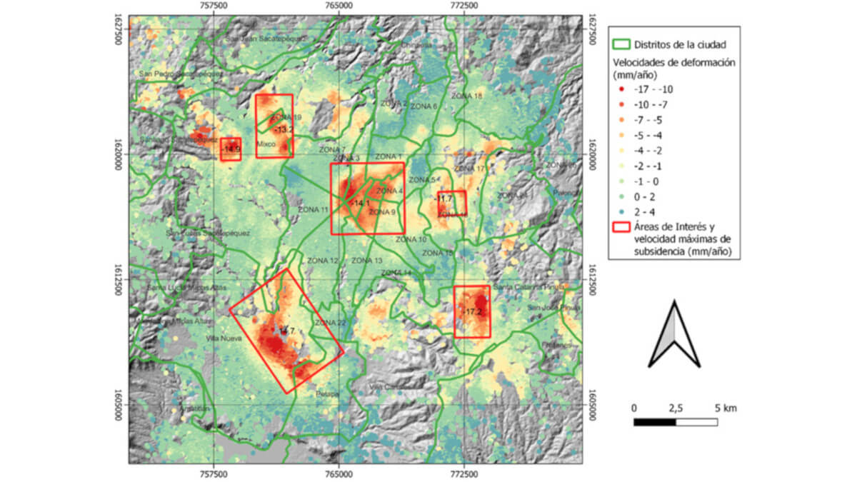
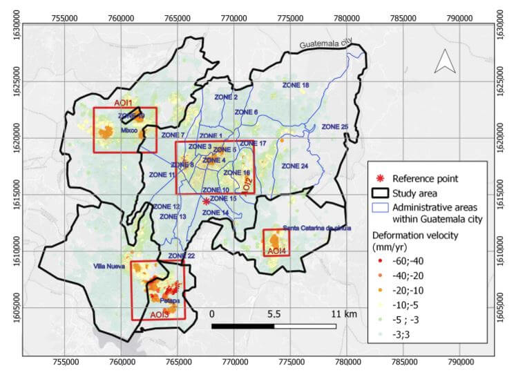
The results make it possible to identify the areas with high subsidence rates, indicating clear subsidence processes during the analyzed study period.
To carry out this work, a total of 226 SAR images from Sentinel-1 A and B were processed in both acquisition geometries (ascending and descending) using the InSAR technique known as Persistent Scatterer Interferometry (PSI). The resulting displacements were then decomposed into vertical and East-West horizontal components.
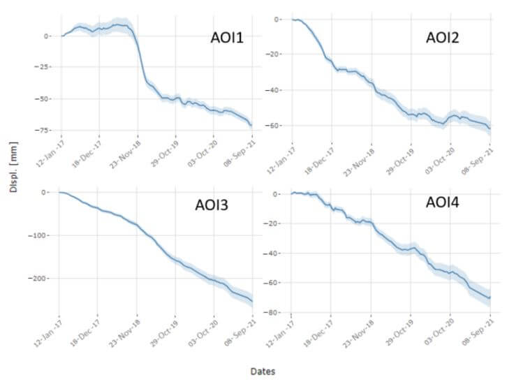
📈 The study allowed the identification and characterization of four major areas experiencing subsidence rates exceeding 1 cm/year. The highest recorded subsidence rates reached values of up to 6 cm/year.
The identified areas are characterized by deformation patterns closely linked to groundwater extraction.
The InSAR results not only helped identify the areas with the greatest deformations (vertical or horizontal), but also allowed for an analysis of deformation trends over time.
This is highly valuable information that can have a significant positive impact on the management of large urban areas. For example:
- We can identify when and where there has been an acceleration, deceleration, or trend reversal in deformation rates.
- We can correlate these changes in deformation velocity with variables such as precipitation, water table level, and groundwater extraction.
- In areas where there is a strong correlation between deformation and groundwater level, we can monitor aquifer recharge and discharge cycles over large areas thanks to InSAR’s high spatial resolution—and all of this non-invasively, without the need for on-site instrumentation or sensors.
- We can detect deformation anomalies and trigger alerts when accumulated deformation or deformation velocity exceeds a predefined threshold.
- We can identify and quantify the impact of urban construction on surrounding buildings or infrastructure.
- We can detect areas with the highest deformation gradients and identify which buildings or infrastructures are undergoing the most significant differential deformation.
- We can calculate structural health metrics to assess and classify the most vulnerable buildings or infrastructures, allowing us to prioritize them and plan preventive or maintenance actions based on consistent, objective data.
At Detektia, we use satellite-based InSAR technology to identify ground subsidence and sinking processes with millimetric precision. We can help you monitor and manage all types of infrastructure and phenomena such as:


This content is a summary of the study published by Detektia in the journal Remote Sensing under the title: “Analysis of Deformation Dynamics in Guatemala City Metropolitan Area Using Persistent Scatterer Interferometry“.
In the study, we evaluated the potential of InSAR technology for monitoring ground deformation in large urban areas. Specifically, we analyzed deformation dynamics in the Guatemala Metropolitan Area, a major urban zone with over 5 million inhabitants, encompassing Guatemala City and several nearby cities located in the Department of Guatemala.
If you’re interested in exploring this topic further, you can read the full study here.
