- 2004 - 2006
- Madrid (Spain)
- Ascending
- Envisat
- Buildings
In this study, InSAR technology was applied to analyze the structural impact of a railway tunnel excavation near Atocha Station, an area with complex geological conditions. Through the analysis of satellite data, millimetric ground settlements were detected, and specific indices were developed to assess the structural health of nearby buildings.
Between 2004 and 2006, a new railway tunnel was excavated near Atocha Station, in the center of Madrid. The tunnel passes through a geologically heterogeneous and complex area, posing a significant challenge in ensuring the structural integrity of surrounding buildings during construction.
Atocha Station and nearby buildings—some of them historic—were at risk of differential settlement and deformation during the works. In this context, monitoring the structural health of adjacent buildings and structures throughout the construction process was essential.
This study was published in a scientific article in 2020 in the International Journal of Digital Earth, shortly after Detektia was founded. Much of Detektia’s current team contributed to the work, which is especially meaningful to us as it marked the beginning of a key research line: structural health indices.
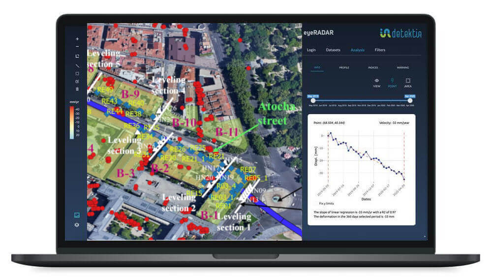
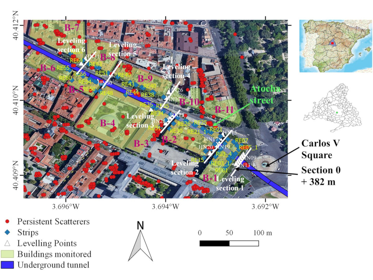
Traditional monitoring methods (such as periodic leveling and gauge strips) were implemented during the construction. This study, carried out after the completion of the works, demonstrates the potential of InSAR technology in this type of project, offering an innovative and complementary solution for continuous, remote, and high-precision monitoring of deformations during construction.
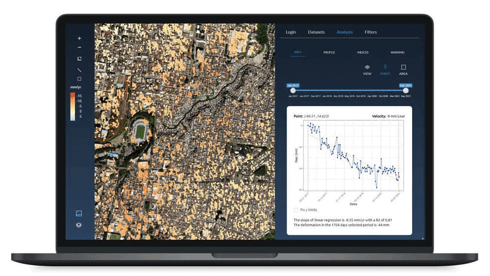
Use of InSAR for Monitoring Affected Areas
InSAR technology was applied to detect and quantify millimetric displacements in the Atocha area during the two years of underground construction. Specifically, ascending-geometry images from the Envisat satellite, available at that time, were used.
Envisat’s spatial and temporal resolution was limited compared to current satellites—approximately one image per month with a resolution of several tens of meters per pixel. However, it was still possible to achieve a sufficiently dense coverage of measurement points (persistent scatterers) on building rooftops and the surrounding terrain.
To assess the structural health of each building, the study proposes several novel classification indices based on InSAR results. These indices synthesize the deformation data from all InSAR points on a building into parameters that can be interpreted by civil engineers. Some of the indices considered include:
- Accumulated Settlement Index (Iacc): measures the total vertical displacement experienced by the building during the construction period.
- Differential Deformation Index (Idiff): quantifies the difference in settlement between different points of the structure (an indicator of potential distortions and differential settlement).
- Deformation Acceleration Index (Iacel): detects sudden changes in the rate of movement, signaling possible anomalous events (e.g., sudden subsidence).
These indices enable objective classification of the degree of impact on each building and support early warning generation. In fact, any significant change in an index following a new satellite image may indicate a variation in structural behavior, triggering alerts for immediate inspection.
All InSAR-derived results were cross-validated with traditional measurements (such as leveling benchmarks on buildings and gauge strips), showing good correlation between both methods. This validation increased confidence in using InSAR as a complementary remote monitoring tool.
Results obtained
InSAR monitoring revealed that most buildings around Atocha experienced moderate settlements—generally within safe limits—during tunnel excavation. However, a detailed building-by-building analysis identified isolated cases of higher differential deformation.
In particular, two historic buildings located near the tunnel alignment showed elevated values in the Idiff index, indicating potentially significant differential deformation during the works.
These two structures, situated on softer soils within a geologically heterogeneous section, exhibited accelerated settlements coinciding with the tunnel boring machine passing directly beneath them. As a result, they were classified as “high risk” according to the structural health index (Ia) defined in the study.
The analysis led to four key findings:
-
Maximum settlement: The highest accumulated displacement observed in a building was approximately 8 mm (measured via InSAR), located in one of the two critical buildings.
-
Differential deformation: In these two buildings, settlement differences of up to ~5 mm were measured between opposite ends of the structure—consistent with minor cracks observed on site.
-
Stable buildings: Other structures in the area showed deformations below concerning thresholds; many experienced homogeneous settlements under 3 mm with no visible damage.
-
In-situ validation: Readings from leveling benchmarks installed at Atocha Station and adjacent buildings confirmed trends similar to those detected by InSAR (within ±1 mm), reinforcing the method’s reliability.
The structural health indices developed in this study translated deformation data into actionable insights. For example, satellite-based monitoring made it possible to detect deformations beyond the instrumented area and recommend additional inspections for buildings showing higher risk index values.
Conclusions
The study demonstrated the significant potential of InSAR technology for monitoring underground construction in sensitive urban environments.
Despite the limitations of the satellites available at the time, millimetric displacements were detected, and the stability of dozens of structures was objectively assessed.
This pioneering case validated that integrating InSAR monitoring with conventional systems provides an additional layer of safety: it enables continuous surveillance of all buildings across a wide area—something unfeasible with traditional instrumentation alone.
The project is described in greater detail in the following scientific article published in 2020: https://www.tandfonline.com/doi/full/10.1080/17538947.2020.1815878.
This study helped lay the groundwork for applying InSAR technology to large urban civil engineering projects, demonstrating that space-based monitoring contributes to protecting the built heritage in our cities while enabling the construction of new infrastructure.
Today, thanks to the availability of satellites with higher temporal and spatial resolution—such as Sentinel-1—we can offer early warning solutions that enhance the information available during tunnel construction in urban environments, monitoring the “health” of each nearby building and ensuring its safety with objective data.