
Joshimath is located at an altitude of 1,890 meters in the Chamoli district of Uttarakhand, India. This town, situated on the slopes of the Himalayas, is bordered by the Dhauliganga and Alaknanda rivers and is located on terrain composed of silty-sandy deposits mixed with gneiss and schist deposits.
In Joshimath, a severe process of land subsidence has been observed for years. This phenomenon is exacerbated by factors such as erosion from heavy rains, infrastructure development, and human activities.
During the year 2022 and 2023 there have been several landslides. In this article we analyze from a technical point of view what happened and how satellite radar technology could have prevented this situation.
Land subsidence of Joshimath, India
In addition to subsidence, the area has recorded landslides, causing large cracks in buildings and sometimes causing them to collapse. Massive land movements are related to heavy rains that intensify the instability of the terrain in the area.
Located on the slopes of the Himalayas, Joshimath is a city where a heavy land subsidence and landslides have happened.
In december 2022, Joshimath witnessed the collapse of some buildings and the appearance of large cracks, mainly due to accelerated land subsidence processes. This event represented a critical threat to the lives of around 20,000 individuals residing in the area.
Analysis of landslides occurred in Joshimath
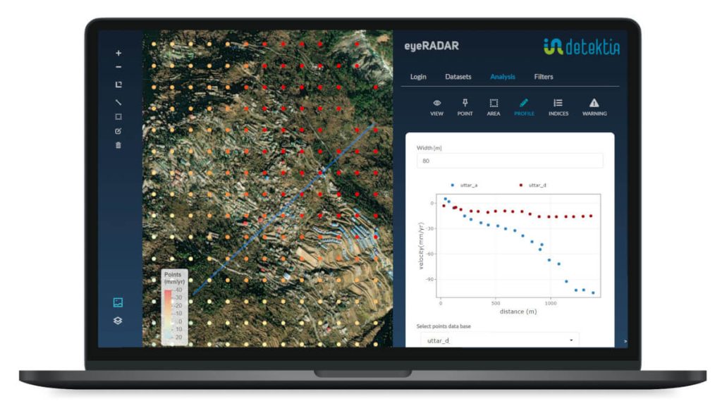
To assess the extent of subsidence and mass movements in the area, Detektia conducted a study using SAR images from the twin Sentinel-1 satellites for a six-year period, from 2017 to 2022.

Through this analysis, time series of deformation were generated that allowed characterising the evolution of movements in the urban area of Joshimath.
In november 22 EEA released the first map of ground deformations using InSAR technology. The use of this type of data could have been used to detect the high erosion occurred in this area. Have a look to our article if you are interested in European Ground Motion Service.
Although residents of the area had been observing cracks in buildings since the last months of 2020, the first documented event of damage induced by subsidence in the region occurred on February 7, 2021, following a significant rockslide.
Detektia has completed a study of subsidence in Joshimath from 2017 to 2022 using SAR satellite imagery.
Subsequently, in October 2021, unprecedented torrential rains in Chamoli resulted in extensive erosion of the Joshimath valley, caused by the strong flow of the rivers. As a consequence of these rains, cracks and subsidence intensified along the roads, and pre-existing cracks in several houses expanded even further.
The analysis of time series of displacement points in Joshimath clearly indicates a distinct pattern of subsidence covering almost the entire valley.
Our study further reveals that Joshimath has been experiencing a gradual sinking process at a rate of 100 mm per year since 2017. This subsidence phenomenon predates the material damage that occurred in 2022. Our analysis showed that during April and November of 2022, the ground sank 8.9 cm, and then the subsidence increased dramatically from December 27, 2022, to January 8, 2023, when the town sank an additional 5.4 cm in just 12 days.
The analysis completed by Detektia yields interesting results: Since 2017, the valley in which the city Joshimath is located has undergone a progressive subsidence of 100 mm per year.
Causes of land subsidence ocurred in Joshimath
The contributing factors to this process are many and varied.
Although no earthquakes have been reported in this area, it is located in the active seismic belt of the Himalayas. The strong water flow in the rivers deeply erodes the base of the Joshimath valley. Both phenomena can cause subsidence due to the displacement of underground objects.
According to assessment reports, the initial slope instability in Joshimath was attributed to two extreme events: an avalanche flow in February 2021 and heavy rains in October 2021. However, satellite data analysis since 2017 reveals that subsidence was a continuous and constant phenomenon in the valley, which had been overlooked until the significant catastrophic event in December 2022.
Other factors are unplanned construction, increasing tourism, and mega infrastructure and energy projects funded by the government. The construction of infrastructure in the Himalayan belt is increasing considerably. Over the last five years, approximately 11,000 km of roads have been built in the Indian Himalayan states (The Tribune, 2022).
The fragility of the landscape and poor construction practices have also led to frequent mass movements in this territory.
Geologists further suspect that the development of the “all-weather” Char Dham road and the 520 MW Tapovan-Vishnugad hydroelectric project of the National Thermal Power Corporation (NTPC) may be the main causes of this rapid land subsidence.
Among the probable causes, we highlight the fact that it is located in the active seismic belt of the Himalayas as well as high unplanned construction activities.
Further studies are needed to understand the complex processes and establish a relationship between the inducing factors, including anthropogenic activities, and the subsidence in Joshimath.
Benefits of InSAR technology in the prevention of this type of situation
The study clearly demonstrates the critical role of satellite radar technology in the effective management of landslide-prone areas.
By leveraging the power of InSAR technology (Interferometric Synthetic Aperture Radar), we can detect and track ground displacements over time, allowing us to identify and monitor areas and times at high risk of landslides. This valuable information enables us to develop and implement early warning systems, significantly reducing the negative impact these events can cause.
Additionally, InSAR allows for the continuous control of slope stability and the assessment of the effectiveness of mitigation measures. If you want to learn more about how Detektia analyse and prevents landslides this content may interest you.
InSAR technology helps on the prevention and detection of landslides.
Integrating satellite-based early warning systems into the information systems of infrastructure stakeholders offers the opportunity to impact decision-making processes in proactive infrastructure management.
This is especially relevant in the current digital era, where the number of assets and areas requiring monitoring is rapidly increasing. Relying solely on ground-based monitoring systems is no longer feasible, considering the scale and complexity of both urban and non-urban infrastructures.
Therefore, the use of satellite data and remote sensing techniques becomes indispensable for providing comprehensive and efficient control solutions.