
6 months of specialized training
- Real-world case analysis
- Hands-on practice and use cases selected by the student
- Live online tutoring
- Private community for Q&A
- 100% practical course
100% online
- Online learning platform
- Over 10 hours of video-based training
- Quizzes and practical exercises
- Downloadable documents
- Lifetime access to course materials
Mentored by InSAR experts
- Mentored by the Detektia team
- Forum and recurring video conferences
- Training led by industry experts
100% up-to-date training
- Continuously updated modules
- Integration of European Ground Motion Service (EGMS) data and the OPERA project DISP product
Access to advanced tools
- Unlimited access to and use of professional tools throughout the training
Practical InSAR Course on Satellite Radar Technology in the Civil Engineering Sector
In the field of civil engineering, the challenge of monitoring deformations in large infrastructures—and even entire cities—is becoming increasingly complex.
Relying solely on instruments and surveying campaigns is no longer enough to track all the deformation processes occurring over extensive areas.
Experts in this field are calling for the integration of new technologies and data sources to enable more efficient infrastructure monitoring.
Radar sensors on satellites generate vast amounts of high-quality, high-resolution data every day. InSAR technology (Synthetic Aperture Radar Interferometry) allows us to measure, with millimeter precision, the movements and deformations of the ground and infrastructures from this enormous volume of information.
When combined with in-situ measurements, this technology is set to transform how we observe, manage, and operate our infrastructures.
If you are a civil engineer, geotechnical engineer, geologist, or participate in any phase of a large infrastructure’s lifecycle (planning, design, construction, or operation), it is essential to understand the satellite technology that will play a key role in monitoring major infrastructures worldwide.
Throughout the course, consisting of 7 modules, 6 live Q&A webinars, discussion forums, and a continuous communication channel with tutors, we will guide you step by step in learning InSAR technology applied to civil infrastructure management.
What past students say about previous editions
InSAR Training in Detail
+-In-Depth InSAR Analysis
We will analyze InSAR technology in detail, understanding the entire process from satellite data to deformation results. We will closely examine all satellite missions and their characteristics, as well as the resolution and accuracy of the different InSAR techniques…
+-Advantages and Disadvantages of InSAR
We will delve into the advantages (and also the limitations) of this technology to understand in which situations it provides the most value. To do this, students will work with real data and use cases that they can select themselves.
+-How InSAR Technology Works
We will understand along which axes InSAR technology measures movements and deformations, and how it is possible to translate these measurements into the user’s axes of interest (vertical axis and planimetry, along the slope direction, etc.). To achieve this, students will carry out exercises decomposing deformation time series on the infrastructure and axes they choose.
+-Integration of InSAR with Other Data
We will explore how to integrate deformation time series measured with InSAR with other data sources from instruments or surveying campaigns.
+-Correlations with Other Variables
We will use advanced tools that allow us to interact with and visualize InSAR deformation time series alongside other important variables in deformation processes, such as temperature, precipitation, or reservoir level (if working with dams)...
+-Essential for Your Measurement Strategy
We will analyze how InSAR technology is a highly useful tool for designing on-site measurement and instrumentation strategies.
+-Real-World Case Studies
We will explore how to analyze and generate aggregated metrics across different structures and areas of interest, helping to characterize the condition and structural health of buildings and infrastructures.
For all of this, Detektia will provide students with a suite of tools that allow them to achieve the course objectives in a fully practical way, using and manipulating real data in the use case of their choice.
For example, if you manage dams, you will be able to analyze historical deformation time series of your own dams during the course, integrating your own topography, piezometry, and reservoir level data. This will give you a more complete understanding of deformation processes and the interaction between different variables.
If you work with linear infrastructures, you can analyze the behavior of the terrain before the design or construction of the infrastructure. You will be able to study slopes or specific areas of interest or responsibility.
If you work on large urban infrastructure projects, you will be able to analyze the behavior of the project’s affected area throughout the course. The same applies to analyzing slopes, port infrastructures, and similar projects.
Tools and Resources We Will Use During the Satellite InSAR Course
The course will use data from the European Ground Motion Service (EGMS) project and OPERA DISP. Whenever the location is in Europe, students will be able to use historical data (from early 2015 to late 2022) for the infrastructures they are working on or those of interest to them.
We believe the best way to learn is by using data that provides real value to the project the student is currently working on.
Students will have access to a set of advanced tools that allow them to analyze InSAR results in a visual, interactive, and efficient way. These tools are:
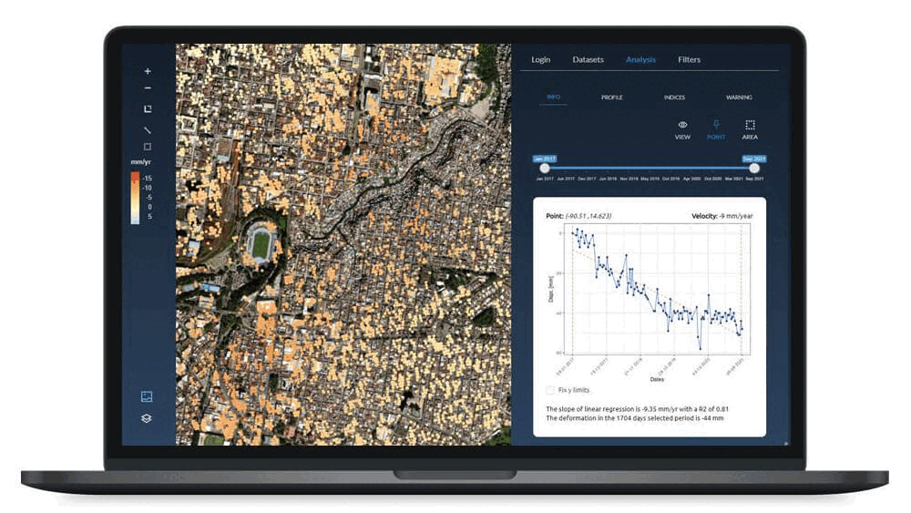
EyeRADAR for Civil Infrastructure Management
EyeRADAR is a web tool that allows you to analyze InSAR results in an interactive and visual way. It also enables the visualization of deformation time series alongside other variables and data sources. During the course, you will have free and unlimited access to EyeRADAR.
Detektia QGIS Plugin for Civil Engineering
The Detektia QGIS plugin allows us to analyze InSAR data while leveraging the full potential of a Geographic Information System (GIS). The course includes hands-on training with this software, which is the leading open-source GIS platform.
Jupyter Notebooks
Jupyter Notebooks with the main InSAR data analysis workflows in Python. If interested, you will be able to start working with InSAR data using this programming language. Basic Python knowledge is required for this part of the course. We will provide introductory guidance so students can use the shared notebooks and begin familiarizing themselves with InSAR result analysis in Python.
We are confident that understanding InSAR technology will be essential for any professional in the civil engineering sector. We have designed a unique, fully practical course where professionals can learn about this technology using InSAR data from their own projects and areas of interest.
FAQs
+-What is the price?
The course price is €1,200. Newsletter subscribers will have priority enrollment with a discount. Subscribing to the newsletter is free of charge.
+-What is the course start date and schedule?
The second edition starts on November 25, 2025. For now, all information is being sent via the newsletter. Subscribe for free to receive all the details.
+-When does the enrollment period close?
The last day to enroll will be November 24, 2025, one day before the course begins. Remember that we are offering significant discounts to newsletter subscribers.
+-What tools and software will be used in the course?
Students will have access to all of Detektia’s analysis tools: the EyeRADAR web tool, our QGIS plugin, and Jupyter Notebooks with InSAR post-processing workflows. For the latter, we will provide a guide to install Jupyter and the necessary Python libraries. All these tools use the Detektia API, which students will have access to throughout the course. The API allows uploading EGMS and OPERA DISP InSAR data, visualizing it, and applying algorithms to decompose measurements into axes of interest, cluster areas with homogeneous behavior, and more. The QGIS plugin tools that do not rely on the API will remain available to students permanently.
+-Is prior knowledge required to take the course?
No, the course only requires a willingness to learn about a technology that will play a key role in monitoring the infrastructures of the future. If you are a civil engineer, geotechnical engineer, geologist, or training in these fields, and you participate in any phase of an infrastructure’s lifecycle, this course is for you—especially if you want to improve the available information on the geotechnical behavior of your area of interest. Don’t worry about prior knowledge; all you need is the desire to learn.
+-Will I learn how to process InSAR data?
No, the course does not include InSAR processing. The InSAR processing workflow is complex and entirely beyond the scope of this course. Learning to understand, analyze, and interpret InSAR results, and managing post-processing and integration with other data sources, is already an ambitious goal. This course is designed for civil engineering professionals. We believe these experts are not expected to perform radar interferometry themselves. Controlling InSAR techniques requires years of experience in satellite remote sensing, as they are significantly more complex than other data analysis methods such as LiDAR or multispectral optical imagery.
+-How long is the course?
The course lasts approximately 6 months. During this time, the different modules will be gradually released, allowing for in-depth exploration of all content. You will always have access to a calendar with module release dates, deadlines, webinars, and other key events.
+-How long will I have access to the course content?
The learning platform will remain open for a total of 6 months. During this time, students can retake tests, complete or improve exercises, and review the course content. Once the platform closes, we will provide all course materials in a compressed file so students can access them at any time.
+-What is the format of the course?
The course has a 100% practical approach. Students will work with InSAR data on real-world use cases. If a student is working on projects in Europe, they can carry out all exercises using data from their own project. The course includes webinars for all modules, evaluation tests, InSAR analysis tools, forums to ask questions at any time, submission of assignments through the learning platform, and manual review by a team of experts in InSAR technology and data science.
Instructors for the Civil Engineering Course
The entire Detektia team has put great effort into designing and creating this course and will be actively involved in its development.
The Detektia team is made up of experts in satellite technologies and data science.
As a spin-off of the Surveying and Geomatics Laboratory at the School of Civil Engineering of the Polytechnic University of Madrid (UPM), the team also includes researchers from the laboratory, who continuously contribute as expert advisors in the technology and civil engineering sector.
Detektia maintains strong ties with academia; most of the team hold doctoral degrees or are in the process of completing them. Knowledge transfer, research, and development are part of our DNA.
The main instructors of the course are:

MSc. Candela Sancho
She has led Detektia since its founding in late 2019. She is an expert in analyzing natural and human-induced processes that drive ground deformation. She has worked for over 7 years in the Geosciences Department at CSIC–Institut Jaume Almera (Barcelona, Spain) and in the Tectonophysics Department at Utrecht University (Utrecht, Netherlands).

Dr. Vrinda Krishnakumar
Civil engineer and expert in satellite DInSAR technology. She holds a PhD from the Universitat Politècnica de Catalunya with a dissertation titled “Sentinel-1 Data Exploitation for Terrain Deformation Monitoring” (2022).

Dr. Álvaro Hernández
Data scientist and PhD in particle physics from the Karlsruhe Institute of Technology. He is an expert in data analysis using C++, Python, and R. For the past two years at Detektia, his work has focused on developing algorithms for analyzing InSAR deformation time series using advanced statistical techniques and machine learning.

MSc. Jaime Sánchez
He is pursuing a PhD on monitoring port infrastructures using InSAR technology. He is a developer in C++, R, Python, and MATLAB, and an expert in developing InSAR workflows and integrating InSAR with AI.

Dr. Alfredo Fernández-Landa
He has over 15 years of experience in remote sensing and is an expert in developing environmental applications using data from remote sensors. He holds a PhD in Remote Sensing from the Polytechnic University of Madrid.

Profesor Dr. Rubén Martínez
Deeply knowledgeable about the civil engineering sector and its needs. He holds a PhD in Civil Engineering, has been an Associate Professor since 2003, and is the director of the Surveying and Geomatics Laboratory at the School of Civil Engineering, UPM.

Profesor Titular Dr. Miguel Marchamalo
He has extensive expertise in satellite RADAR technology and its applications in the environmental, water, and civil engineering sectors.
DInSAR Course Format
The course will be 100% online. For each module, we will hold a live online class to address all questions related to the content. Throughout the course, participants will be able to ask questions through a forum or directly to the course tutors.
Modules of the Civil Infrastructure InSAR Training

Module 1: InSAR Technology
In this module, we will delve into InSAR technology. It is the most theoretical module but essential for understanding the information we will use throughout the rest of the course.
The main topics include: Synthetic Aperture Radar (SAR) data, geometric distortions, SAR bands and characteristics, past, current, and future SAR satellite missions, InSAR fundamentals, interferograms, types of scatterers, InSAR techniques, accuracies, resolutions, and the main advantages and limitations.
Module 2: The European Ground Motion Service Project
The European Ground Motion Service (EGMS) project provides continent-wide, homogeneous information on ground movements with millimeter precision and annual updates. Currently, deformation data are available for a six-year period (2015–2021) and a second five-year update (2018–2022).
This project allows us to work with InSAR data for the course anywhere in Europe.
The main topics include: project overview, available information, EGMS data characteristics, available products, accuracy, update frequency, and data download.


Module 3: OPERA Project DISP Product
The OPERA DISP project by NASA provides continent-wide, homogeneous information on ground displacements across North America, with a 30-meter resolution and updates every 6 to 12 days. Historical time series from 2016, generated using Sentinel-1 data, are currently available, and observations from the NISAR mission are expected to be integrated soon, improving coherence in vegetated areas and expanding analysis possibilities.
This project makes highly valuable InSAR data available for work in the U.S., large parts of Canada, Mexico, and all of Central America.
The main topics include: project and InSAR technique overview, geographic coverage, DISP data characteristics, spatial and temporal resolution, update frequency, accuracy, and data access.
Module 4: Motion Decomposition
In this module, we will learn how to decompose the movements measured by InSAR technology into the user’s axes of interest.
This is a fundamental aspect for fully leveraging the technology; we need to measure movements along axes that help us better understand deformation processes. Students will be able to practice motion decomposition in the use cases and situations they choose.
For example, a student can decompose the movements of a slope considering its orientation and incline, or measure the movements of a hillside along the same axes as installed inclinometers. If analyzing a dam, it is possible to decompose movements along the same axes used in topographic measurements.

Module 5: InSAR Results Analysis in QGIS
The Detektia QGIS plugin allows working with InSAR data within QGIS, the leading open-source Geographic Information System.
In this module, we will cover the basic use of QGIS so that users unfamiliar with this GIS can use the plugin without issues. We will go through all the plugin’s functionalities, learn how to decompose movements using the plugin, analyze deformations in 3D alongside LiDAR point clouds, and combine InSAR data with advanced site information (geology, construction units, structural elements…) or with metrics and alerts generated for our use case.
Módulo 6: Herramienta web EyeRADAR
The EyeRADAR web tool allows interactive and visual analysis of InSAR results. It offers multiple graphing and analysis functionalities to maximize the value of InSAR data. Additionally, deformation time series can be integrated with other variables and data sources, correlations can be analyzed, and deformation results from different measurement techniques can be compared—all without needing to install any additional software.
In this module, we will learn how to analyze InSAR results from various use cases using this web tool.
Module 7: InSAR Time Series Analysis with Python
Python has become a fundamental tool for data analysis. In this module, we will share basic workflows for analyzing InSAR data with Python: loading and downloading InSAR or in-situ data, data filtering, motion decomposition, correlation analysis, and more.
Students will perform exercises using real data from the specific infrastructures that interest them.