
Radar remote sensing technology has revolutionised the way we perceive and understand our world. But similar to other remote sensing sensors a radar system also has its unique set of challenges when it comes to creating accurate images.
SAR data can be a bit distorted because of how the sensor works, especially in rough terrains with varying topography. Radiometric terrain correction is a method to fix these distortions and make sure the data matches up with other maps and can be used for things like GIS. In this post, we will explore the peculiar distortions that radar imagery can exhibit due to its side-looking viewing geometry and its nature as a distance-measuring device.
Slant-Range Scale Distortion
One of the primary distortions encountered in radar imagery is slant-range scale distortion. Unlike cameras or scanners that measure true horizontal distances along the ground, radar calculates distances in slant range. This leads to varying image scales from near to far range. Even though objects on the ground may be the same size, their apparent dimensions in slant range can be different. As a result, targets in the near range can appear compressed relative to those in the far range. Fortunately, trigonometry can help us calculate the ground-range distance from slant-range distance and platform altitude, converting it into a proper ground-range format.
Relief Displacement
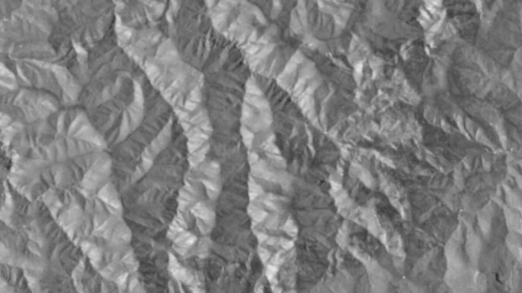
Similar to other imaging systems, radar images are also subject to geometric distortions due to relief displacement. When we look at a sloping terrain compared to a flat surface, more distortions happen in radar imagery. This displacement occurs one-dimensionally and is perpendicular to the flight path. However, radar displacement differs in that targets are displaced towards the sensor rather than away from it. This phenomenon leads to two important consequences: radar foreshortening and layover.
Radar Foreshortening
Foreshortening occurs when the radar beam reaches the base of a tall feature (like a mountain) before it reaches the top. As radar measures distance in slant range, the slope facing the radar will appear as a narrow compressed bright band, and the length of the slope will be inaccurately represented in the resulting image. The severity of foreshortening depends on the angle of the hillside or mountain slope in relation to the radar beam’s incidence angle. It happens when the terrain slope is close to the radar incidence angle, Maximum foreshortening occurs when the radar beam is perpendicular to the slope, effectively reducing the length of the slope to zero in slant range.
Radar Layover
When the slope of the land becomes even steeper than the angle at which the radar looks at the scatterers (objects that reflect radar signals), the top of the slope might get imaged before the ones from the bottom. These images start to overlap with data from other areas. We call this effect “layover.” Layover also happens when the radar beam reaches the top of a tall feature before it reaches the base. This leads to the top of the feature being displaced towards the radar and “laying over” the base. Layover effects can resemble foreshortening, and their severity is influenced by factors such as incidence angles, near range, and terrain. In this case, the data from the front slope cannot be extracted from the returns.
Radar Shadow
Both foreshortening and layover contribute to radar shadow. Shadow occurs when the radar beam cannot illuminate the ground surface. These shadows occur in the down-range dimension, behind vertical features or steep slopes. In shadowed regions, no energy is available to be backscattered, resulting in dark areas on the radar image. As the incidence angle increases from near to far range, shadow effects become more pronounced.
When radiometric corrections are performed on the radar images, foreshortened areas are corrected based on the digital elevation models. Areas impacted by layover or shadow, however, do not actually have data returns to correct. In this case, the pixels in the resulting corrected image will usually have a value of No Data.

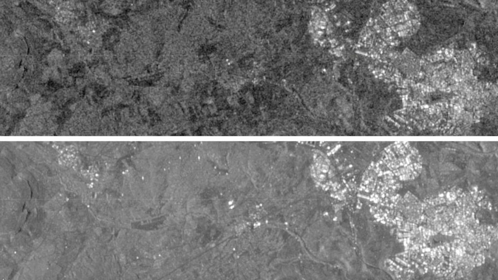
Speckle
Usually, when a SAR transmitter sends signals, the ground it hits isn’t all the same. It’s made up of different things that can bounce the signals around in different ways. Sometimes this makes the SAR image look kind of grainy, like salt and pepper. This grainy effect happens in all SAR images because of how SAR works. To make the image look smoother, you can use a technique called multi-looking, which basically averages things out by taking more images of the same area at different times or from slightly different look angles, but it might make the image less detailed.
Despite these distortions, radar’s side-looking geometry is precisely what makes it invaluable for terrain analysis. In fact, these effects, when not overly severe, enhance the visual representation of relief and terrain structure. This unique capability makes radar imagery an excellent tool for applications like topographic mapping and identifying geological structures.
In conclusion, understanding the geometric distortions in radar imagery is crucial for accurately interpreting the information it provides. By grasping the effects of slant-range scale distortion, relief displacement, foreshortening, layover, and shadow, we can harness radar’s capabilities to gain valuable insights into our dynamic world.
References
- Cover image was downloaded from: https://freepik.es/foto-gratis/nave-espacial-orbita-planeta-vigilando-descubrimiento-extraterrestres-espacio-ultraterrestre-generado-ia_47600566.htm#query=satellite&position=0&from_view=search&track=sph
- Summary of the radar foreshortening image was downloaded from: https://hyp3-docs.asf.alaska.edu/guides/introduction_to_sar/